ITRF2005
Description
$$\global\def\fig#1{\scriptsize\textcolor{E83E8C}{fig.#1}}$$
Unlike the previous versions of the ITRF, the ITRF2005 is constructed with input data under the form of time series of station positions and EOPs. The ITRF2005 input time-series solutions are provided in a weekly sampling by the IAG International Services of satellite techniques (IGS, ILRS and IDS) and in a daily (VLBI session-wise) basis by the IVS. Each per-technique time-series is already a combination, at a weekly basis, of the individual AC solutions of that technique, except for DORIS.
Input data
Space geodesy solutions. The used time series of solutions of space geodesy are summarized in the following table, indicating for each one, the time span and the type of constraints.
| TC - AC | Time span | Type of constraints/solution | Description |
|---|---|---|---|
| IVS | 1980.0 - 2006.0 | Normal equation | Summary |
| ILRS | 1992.9 - 2005.9 | Loose / variance-covariance | Summary |
| IGS | 1996.0 - 2006.0 | Minimal/Inner; variance-covariance | Summary |
| IDS-IGN-JPL | 1993.0 - 2006.0 | Loose / variance-covariance | Summary |
| IDS-LCA | 1993.0 - 2005.8 | Loose / variance-covariance | Summary |
IDS-LCA solution
L. Soudarin (CLS)
J.F. Crétaux (LEGOS-GRGS)
A series of weekly station coordinates and daily pole coordinates has been computed using 13 years (January 1993 to December 2005) of DORIS measurements collected by the instruments onboard SPOT2, SPOT3, SPOT4, SPOT5, TOPEX/Poseidon and ENVISAT. The tracking data are processed nominally on 3.5-day arc (half a week of the GPS calendar) for all the 6 satellites using the GINS/DYNAMO software of the GRGS. Individual normal equations are accumulated to form weekly combined matrices. The inversion of these matrices yields the weekly solutions for the geodetic parameters. This time series of site and pole coordinates is expressed in free network with loose constraints (10 meter and 500 mas respectively). The coordinate solutions are expressed at the median epoch of the week. Pole coordinates are estimated daily at 12:00. The gravity field model used in the orbit computation is GRIM5-C1.
Computation strategy
$$\global\def\fig#1{\scriptsize\textcolor{E83E8C}{fig.#1}}$$
The strategy adopted for the ITRF2005 generation consists in the following steps, illustrated in $\fig1$:
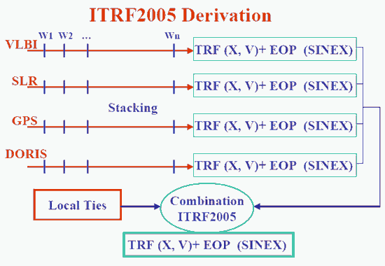
- Apply minimum constraints equally to all loosely constrained solutions: this is the case of SLR and DORIS solutions
- Apply No-Net-Translation and No-Net-Rotation condition to IVS solutions provided under the form of Normal Equation
- Use as they are minimally constrained solutions: this is the case of IGS weekly solutions
- Form per-technique combinations (TRF + EOP), by rigorously staking the time series, solving for station positions, velocities, EOPs and 7 transformation parameters for each weekly (daily in case of VLBI) solution w.r.t the per-technique cumulative solution.
- Identify and reject/de-weight outliers and properly handle discontinuities using piece-wise approach. The discontinuity files used for each one of the 4 techniques are found here.
- Combine if necessary cumulative solutions of a given technique into a unique solution: this is the case of the two DORIS solutions.
- Combine the per-technique combinations adding local ties in co-location sites.
This final step yields the final ITRF2005 solution comprising station positions, velocities and EOPs. Note that EOPs start in the early eighties with VLBI, SLR and DORIS contribution starts on 1993 and GPS on 1999.5. The quality of the early VLBI EOPs is not as good as the combined EOPs starting on 1993.
Frame Definition
Origin
The ITRF2005 origin is defined in such a way that there are null translation parameters at epoch 2000.0 and null translation rates between the ITRF2005 and the ILRS SLR time series.
Scale
The ITRF2005 scale is defined in such a way that there are null scale factor at epoch 2000.0 and null scale rate between the ITRF2005 and IVS VLBI time series.
Orientation
The ITRF2005 orientation is defined in such a way that there are null rotation parameters at epoch 2000.0 and null rotation rates between the ITRF2005 and ITRF2000. These two conditions are applied over a core network (see section transformation parameters between ITRF2005 and ITRF2000).
Scale and Geocenter time series
Detrended Plots
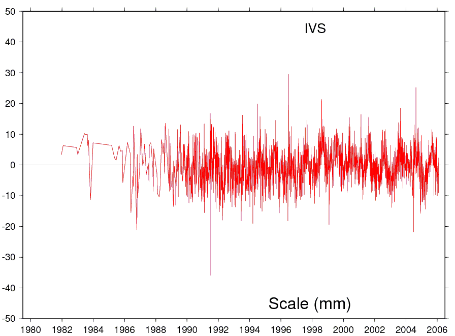
VLBI (Scale)
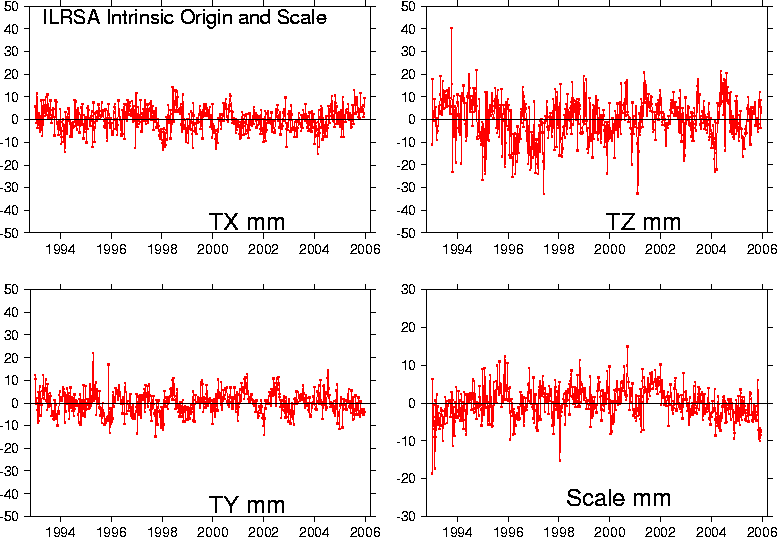
SLR (Scale & Geocenter)
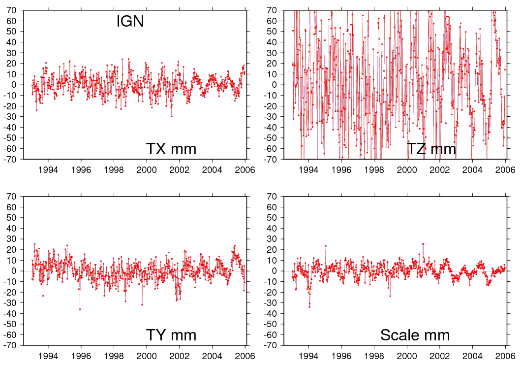
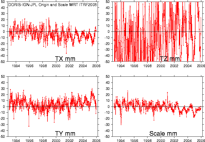
DORIS / IGN / JPL (Scale & Geocenter)
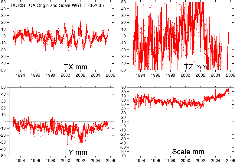
DORIS / LCA (Scale & Geocenter)
Plots with respect to ITRF2005
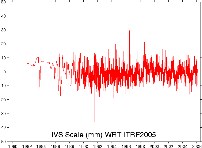
VLBI (Scale)
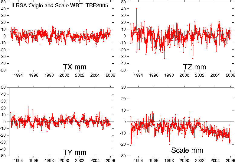
SLR (Scale & Geocenter)
DORIS / IGN / JPL (Scale & Geocenter)
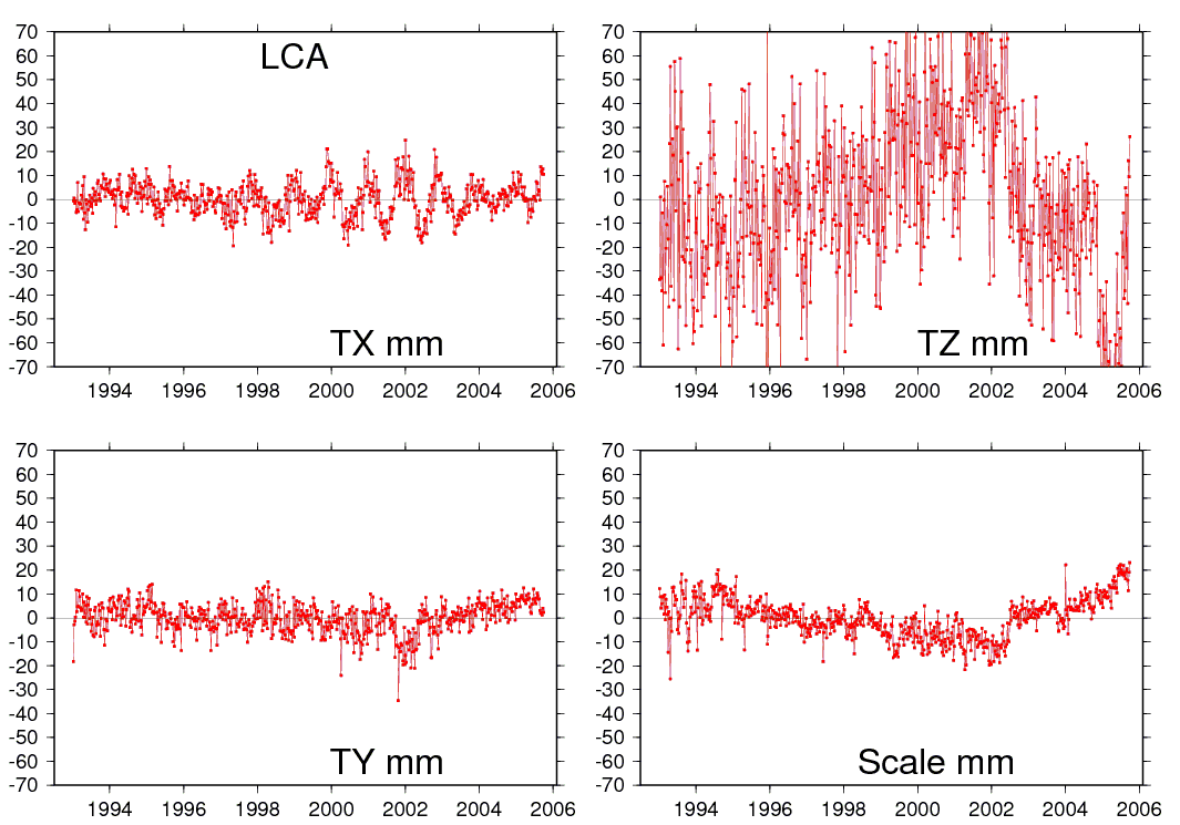
DORIS / LCA (Scale & Geocenter)
ITRF2005 files
Station residuals files
The first step of ITRF2005 strategy is the independent computation of a long-term stacked TRF for each measurement technique under the assumption of linear motions. The associated EOPs are readjusted at the same time to make them consistent with their stacked TRFs. A break-wise approach is used to take into account discontinuities in the time series coming from any physical motion of the ground caused by an earthquake or a change in equipment.
The residuals of these computations, based on the standard relationship linking 2 frames, represent the non-linear part of point behaviors with respect to the secular frame. They can consequently be interpreted as point motions viewed by space geodesy.
Download zip files of time series residuals expressed in the local frame
File format description: yyyy.yyyyy res sig soln
- yyyy.yyyyy : epoch in decimal year.
- res : residual value in millimeter in North , East and Up component depending on the file extension (.DN)(.DE) and (*.DH) respectively.
- sigma: 1-sigma formal error.
- soln : solution number (see the discontinuity file).
SINEX and other files
The ITRF2005 files are available via FTP :
- host: itrf-ftp.ign.fr
- folder: pub/itrf/itrf2005
Notes: Users of ITRF2005 SINEX files should be aware that the standard deviations listed in the field STD_DEV of the +SOLUTION/ESTIMATE block are scaled by the Root Square of the Variance Factor (RSVF) of the ITRF2005 combination. The RSVF is equal to 0.690717136561903. The Variance-Covariance matrices of the ITRF2005 SINEX files are not scaled by the variance factor.
SSC files
Tables of ITRF2005 coordinates
- VLBI Station Positions/Velocities table (ssc format)
- SLR Station Positions/Velocities table (ssc format)
- GNSS Station Positions/Velocities table (ssc format)
- DORIS Station Positions/Velocities table (ssc format)
Discontinuity files
IERS whole network file at the time of ITRF2005
For SLR users of the ITRF2005
Because the ITRF2005 combination revealed a scale inconsistency between SLR and VLBI solutions of 1.0 ppb at epoch 2000.0 and a scale rate of 0.08 ppb/yr, and the fact that the ITRF2005 scale is defined by VLBI, it was decided to make available to SLR users an SLR solution extracted from the ITRF2005 and re-scaled back by the aforementioned scale and scale rate. This solution is available by FTP provided in two SINEX files:
- ITRF2005 ILRS rescaled{.dlLink target=_blank}: station positions expressed at epoch 2000.0
- ITRF2005 ILRS rescaled-MV{.dlLink target=_blank}: station positions expressed at epochs of minimum variances
Two corresponding tables listing station positions and velocities with their sigmas are also available:
For any question or assistance, please don't hesitate to contact us
Transformation Parameters from ITRF2005 to ITRF2000
$$\global\def\fig#1{\scriptsize\textcolor{E83E8C}{fig.#1}}$$
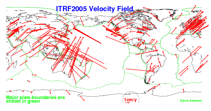
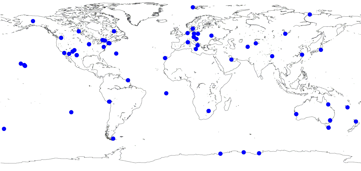
14 transformation parameters from ITRF2005 to ITRF2000 have been estimated using 171 stations listed in the core network list and located at 131 sites shown on the map below ($\fig2$).
| T1 mm |
T2 mm |
T3 mm |
D 10-9 |
R1 mas |
R2 mas |
R3 mas |
|
|---|---|---|---|---|---|---|---|
| 0.1 | -0.8 | -5.8 | 0.40 | 0.000 | 0.000 | 0.000 | |
| $\pm$ | 0.3 | 0.3 | 0.3 | 0.05 | 0.012 | 0.012 | 0.012 |
| Rates | -0.2 | 0.1 | -1.8 | 0.08 | 0.000 | 0.000 | 0.000 |
| $\pm$ | 0.3 | 0.3 | 0.3 | 0.05 | 0.012 | 0.012 | 0.012 |
Acknowledgement
Altamimi, Z., X. Collilieux, J. Legrand, B. Garayt, and C. Boucher (2007), ITRF2005: A new release of the International Terrestrial Reference Frame based on time series of station positions and Earth Orientation Parameters , J. Geophys. Res., 112, B09401.