ITRF2008
Description
$$\global\def\fig#1{\scriptsize\textcolor{E83E8C}{fig.#1}}$$
ITRF2008 is the new realization of the International Terrestrial Reference System. Following the procedure already used for the ITRF2005 formation, the ITRF2008 uses as input data time series of station positions and EOPs provided by the Technique Centers of the four space geodetic techniques (GPS, VLBI, SLR, DORIS). Based on completely reprocessed solutions of the four techniques, the ITRF2008 is expected to be an improved solution compared to ITF2005.
Input data
Space geodesy solutions. The used time series of solutions of space geodesy are summarized in the following table, indicating for each one, the time span and the type of constraints.
Computation strategy
$$\global\def\fig#1{\scriptsize\textcolor{E83E8C}{fig.#1}}$$
The strategy adopted for the ITRF2008 generation consists in the following steps, illustrated in $\fig2$:
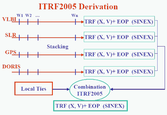
- Apply minimum constraints equally to all loosely constrained solutions: this is the case of SLR solutions
- Apply No-Net-Translation and No-Net-Rotation condition to IVS solutions provided in the form of Normal Equation
- Use as they are minimally constrained solutions: this is the case of IGS and IDS weekly solutions
- Form per-technique combinations (TRF + EOP), by rigorously staking the time series, solving for station positions, velocities, EOPs and 7 transformation parameters for each weekly (daily in case of VLBI) solution w.r.t the per-technique cumulative solution.
- Identify and reject/de-weight outliers and properly handle discontinuities using piece-wise approach. The discontinuity files used for each one of the 4 techniques are found here.
- Combine the per-technique cumulative solutions adding local ties in co-location sites.
This last step yields the final ITRF2008 solution comprising station positions, velocities and EOPs. Note that EOPs start in the early eighties with VLBI and SLR, while DORIS contribution starts from 1993 and GPS from 1997.0.
Frame Definition
Origin
The ITRF2008 origin is defined in such a way that there are null translation parameters at epoch 2005.0 and null translation rates between the ITRF2008 and the ILRS SLR time series.
Scale
The ITRF2008 scale is defined in such a way that there null scale and scale rate between ITRF2008 and the average of VLBI and SLR scales/rates.
Orientation
The ITRF2008 orientation is defined in such a way that there are null rotation parameters at epoch 2005.0 and null rotation rates between the ITRF2008 and ITRF2005. These two conditions are applied over a core network (see section transformation parameters between ITRF2008 and ITRF2005)
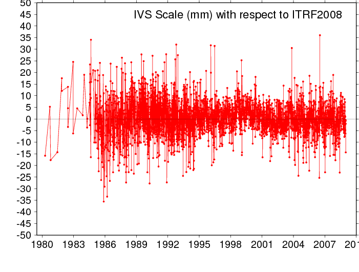
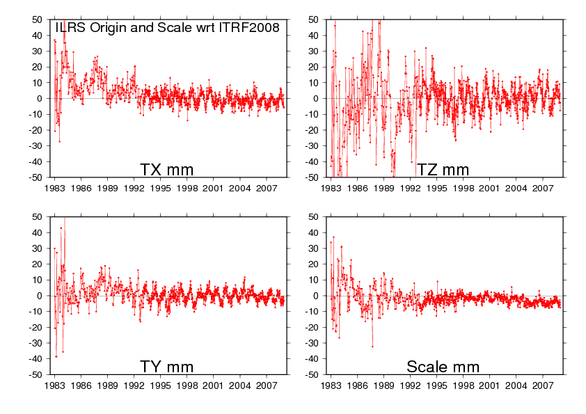
Scale and Geocenter time series
Plots with respect to ITRF2008
VLBI (Scale)
SLR (Scale & Geocenter)
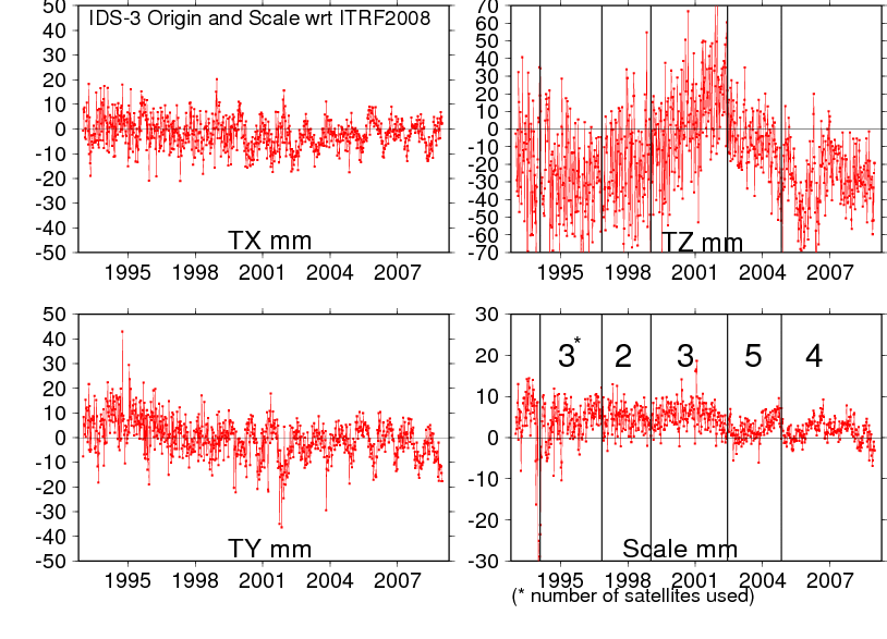
DORIS (Scale & Geocenter)
ITRF2008 files
Station residuals files
The first step of ITRF2008 strategy is the independent computation of a long-term stacked TRF for each measurement technique under the assumption of linear motions. The associated EOPs are readjusted at the same time to make them consistent with their stacked TRFs. A break-wise approach is used to take into account discontinuities in the time series coming from any physical motion of the ground caused by an earthquake or a change in equipment.
The residuals of these computations, based on the standard relationship linking 2 frames, include the non-linear part of point behaviors with respect to the secular frame.
Important notice: translation, rotation and scale parameter time series have been adjusted during the processing of the long-term stacked frames. These parameters have absorbed some of the non-linear variations related to loading effects, especially in the vertical component due to the scale adjustment. As a consequence, ITRF2008 residuals do not supply total station non-linear motions as observed by the space geodetic techniques. See the discussion in section 2.3 of Collilieux et al., 2007.
Download tar files of time series residuals expressed in the local frame
File format description: yyyy.yyyyy res sig soln
- yyyy.yyyyy : epoch in decimal year.
- res : residual value in millimeter in North , East and Up component depending on the file extension (.DN)(.DE) and (*.DH) respectively.
- sigma: 1-sigma formal error.
- soln : solution number (see the discontinuity file).
References: Collilieux, X., Z. Altamimi, D. Coulot, J. Ray and P. Sillard (2007) Comparison of very long baseline interferometry, GPS, and satellite laser ranging height residuals from ITRF2005 using spectral and correlation methods, Journal of Geophysical Research, 112(B12403).
SINEX and other files
The ITRF2008 files are available via FTP :
- host: itrf-ftp.ign.fr
- folder: pub/itrf/itrf2008
SSC files
Tables of ITRF2008 coordinates
- VLBI Station Positions/Velocities table (ssc format)
- SLR Station Positions/Velocities table (ssc format)
- GNSS Station Positions/Velocities table (ssc format)
- DORIS Station Positions/Velocities table (ssc format)
Discontinuity files
Some stations have several coordinates supplied in the ITRF2008 solution. Each coordinate (position and velocity) is identified by an integer number called solution number (soln). Coordinates for each soln are valid for a period supplied in the discontinuity files. These periods may be different from the periods stored in the epoch block of the SINEX file which correspond to the observation spans used to determine ITRF2008 coordinates. They do not always reflect the exact epoch of the event that cause the discontinuity in the position time series when it is known that's why these files supply complementary information.
IERS whole network file at the time of ITRF2008
ITRF2008 tie and space geodesy discrepancies
Transformation Parameters from ITRF2008 to ITRF2005
$$\global\def\fig#1{\scriptsize\textcolor{E83E8C}{fig.#1}}$$
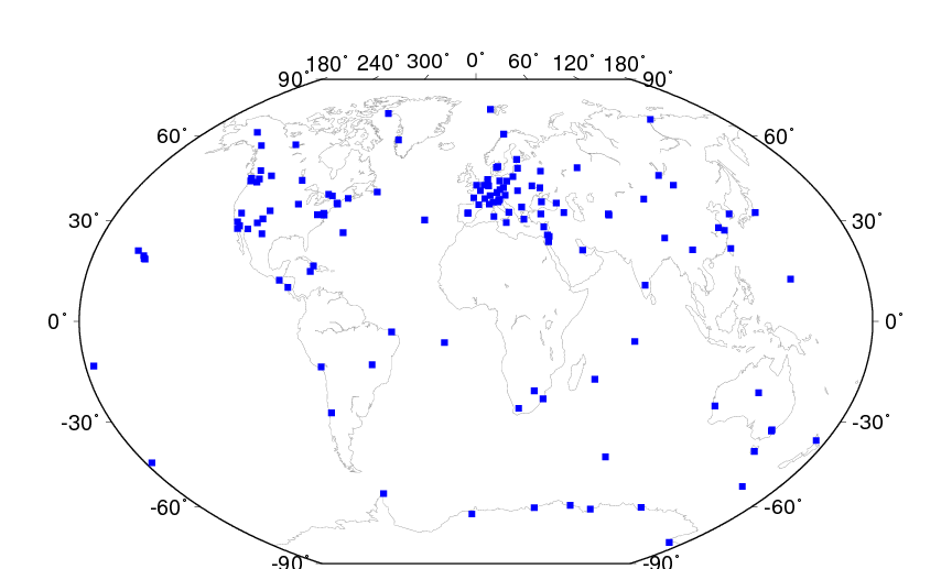
14 transformation parameters from ITRF2008 to ITRF2005 have been estimated using 171 stations listed in the core network list and located at 131 sites shown on the map below ($\fig4$).
| T1 mm |
T2 mm |
T3 mm |
D 10-9 |
R1 mas |
R2 mas |
R3 mas |
|
|---|---|---|---|---|---|---|---|
| -0.5 | -0.9 | -4.7 | 0.94 | 0.000 | 0.000 | 0.000 | |
| $\pm$ | 0.2 | 0.2 | 0.2 | 0.03 | 0.008 | 0.008 | 0.008 |
| Rates | 0.3 | 0.0 | 0.0 | 0.00 | 0.000 | 0.000 | 0.000 |
| $\pm$ | 0.2 | 0.2 | 0.2 | 0.03 | 0.008 | 0.008 | 0.008 |
Acknowledgement
The IERS ITRS Product Center is indebted to the Technique Services (IDS, ILRS, IGS and IVS) and their Analysis and Combination Centers for their contribution by providing reprocessed solutions. The quality of the ITRF2008 is certainly benefiting from these technique improved solutions. Many institutions and individuals have also contributed to the ITRF2008 project. We also acknowledge the contribution of DGFI colleagues to the ITRF2008 analysis.
The IERS ITRS Product Center is particularly grateful to all the institutions who provide the necessary investment for the space geodetic observatories which constitute the main ITRF foundation.