ITRF2020
Description
ITRF2020 is the new realization of the International Terrestrial Reference System. Following the procedure already used for previous ITRF solutions, the ITRF2020 uses as input data time series of station positions and Earth Orientation Parameters (EOPs) provided by the Technique Centers of the four space geodetic techniques (VLBI, SLR, GNSS and DORIS), as well as local ties at colocation sites. Based on completely reprocessed solutions of the four techniques, the ITRF2020 is expected to be an improved solution compared to ITF2014. A number of innovations were introduced in the ITRF2020 processing, including:
- The time series of the four techniques were stacked all together, adding local ties and equating station velocities and seasonal signals at colocation sites;
- Annual and semi-annual terms were estimated for stations of the 4 techniques with sufficient time spans;
- Post-Seismic Deformation (PSD) models for stations subject to major earthquakes were determined by fitting GNSS/IGS data. The PSD models were then applied to the 3 other technique time series at earthquake colocation sites.
Input data
Space geodesy solutions from 4 space geodesy techniques. The used time series of solutions of space geodesy are summarized in the following table, indicating for each one, the time span and the type of constraints.
Computation strategy
The strategy adopted for the ITRF2020 generation consists in rigorously stacking the time series of solutions from the four space geodetic techniques all together, adding local ties and equating station velocities and seasonal signals at colocation sites. To that end, intermediate steps listed below were operated in order to mainly identify and reject outliers and properly assign and handle discontinuities and Post-Seismic Deformation (PSD) models for stations subject to major earthquakes.
The main intermediate steps operated prior to the overall ITRF2020 combination are:
- Apply minimum constraints equally to all loosely constrained solutions: this is the case of SLR weekly solutions;
- Apply No-Net-Translation and No-Net-Rotation constraints to IVS solutions provided in the form of normal equations;
- Use as they are minimally constrained solutions: this is the case of IGS daily and IDS weekly solutions;
- PSD parametric models were determined using GNSS/IGS data, and then applied to all technique time series at earthquake colocation sites, prior to the next step;
- Form per-technique long-term solutions (TRF + EOP), by rigorously stacking the time series, solving for station positions, velocities, EOPs and 7 transformation parameters for each weekly (daily in case of GNSS and session-wise for VLBI) solution with respect to the per-technique cumulative solution. During the iterative stacking process:
- Annual and semi-annual signals were estimated for stations with sufficient time-spans;
- For the particular case of IGS time series, in addition of the annual and semi-annual signals, periodic signals at the first 8 GPS draconitic harmonics were estimated and then removed from the IGS time series.
- PSD model corrections were applied to earthquake sites, prior to the construction of the normal equation of the stacking of the time series.
Frame Definition
Origin
The origin of the ITRF2020 long-term frame is defined in such a way that there are zero translation parameters at epoch 2015.0 and zero translation rates between the ITRF2020 and the ILRS SLR long-term frame over the time-span 1993.0-2021.0, using the concept of internal constraints.
The origin of the ITRF2020 seasonal signals expressed in the CM (as sensed by SLR) frame is defined in such a way that there is no seasonal translation between the ITRF2020 seasonal signals and the input SLR solutions over the time-span 1993.0-2021.0, using the concept of internal constraints.
The origin of the ITRF2020 seasonal signals expressed in the CF frame is defined in such a way that the weighted sum of the seasonal signals of a selected subset of stations (approximating an integral over the Earth’s surface) is zero.
Scale
The scale of the ITRF2020 long-term frame is determined using internal constraints, in such a way that there are zero scale and scale rate between ITRF2020 and the scale and scale rate averages of VLBI selected sessions up to 2013.75 and SLR weekly solutions covering the time-span 1997.7 – 2021.0.
The scale of the ITRF2020 seasonal signals, expressed in both the CM and CF frames, is determined using internal constraints, in such a way that the average of the seasonal scale variations between the selected SLR solutions and ITRF2020 is zero.
Orientation
The orientation of the ITRF2020 long-term frame is defined in such a way that there are zero rotation parameters at epoch 2015.0 and zero rotation rates between the ITRF2020 and ITRF2014. These two conditions are applied over a core network (see section transformation parameters between ITRF2020 and ITRF2014).
The orientation of the ITRF2020 seasonal signals, expressed in both the CM and CF frames, is defined in such a way that there is no net seasonal rotation of that same core network.
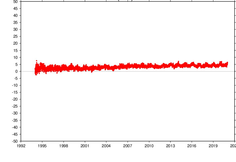
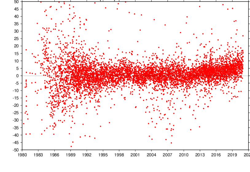
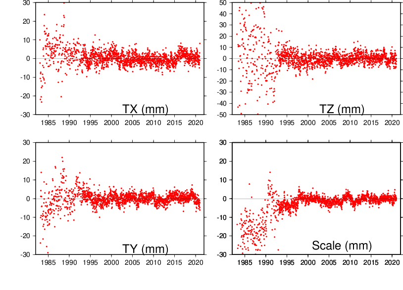
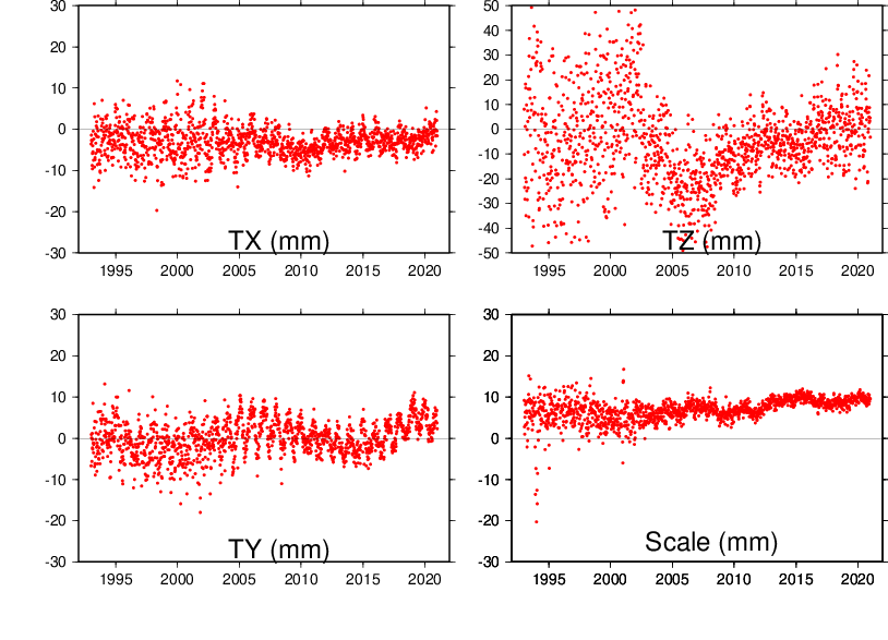
Scale and Geocenter time series
Plots with respect to ITRF2020
GNSS (Scale)
VLBI (Scale)
SLR (Scale & Geocenter)
DORIS (Scale & Geocenter)
ITRF2020 files
SINEX and other files
The ITRF2020 files are available via FTP :
 ftp itrf-ftp.ign.fr
cd pub/itrf/itrf2020| Description | Download link |
|---|---|
| IVS Station positions & velocities without variance-covariance matrix | |
| Table of VLBI Station positions & velocities | |
| IVS Station positions & velocities | |
| IVS Station positions & velocities & EOPs starting from 1979.0 | (18.0 Gb) |
| ILRS Station positions & velocities without variance-covariance matrix | |
| Table of SLR Station positions & velocities | |
| ILRS Station positions & velocities | |
| ILRS Station positions & velocities & EOPs starting from 1983.0 | (17.8 Gb) |
| IGS Station positions & velocities without variance-covariance matrix | (3.2 Gb) |
| Table of GNSS Station positions & velocities | |
| IGS Station positions & velocities | (3.2 Gb) |
| IGS Station positions & velocities & EOPs starting from 1994.0 | (27.0 Gb) |
| IDS Station positions & velocities without variance-covariance matrix | |
| Table of DORIS Station positions & velocities | |
| IDS Station positions & velocities | |
| IDS Station positions & velocities & EOPs starting from 1993.0 | (12.9 Gb) |
| Complete EOP list file: one line per day (MJD) listing all parameters estimated for that day. | |
| Complete EOP list file: one parameter per line | |
| 4 files (one per technique) of station discontinuities, in SINEX format | VLBI SLR GNSS DORIS |
| 4 files (one per technique) of post-seismic deformation model parameters, in CATREF internal format | VLBI SLR GNSS DORIS |
| 4 files (one per technique) of post-seismic deformation model parameters, in SINEX format | VLBI SLR GNSS DORIS |
| Coefficients of the annual and semi-annual signals in XYZ expressed in SLR CM frame | .dat .snx |
| Coefficients of the annual and semi-annual signals in ENU expressed in SLR CM frame | .dat .snx |
| Coefficients of the annual and semi-annual signals in XYZ expressed in the CF frame | .dat .snx |
| Coefficients of the annual and semi-annual signals in ENU expressed in the CF frame | .dat .snx |
| ITRF2020 seasonal geocenter motion model | |
| ITRF2020 seasonal geocenter motion model in SINEX format | |
| Equations for post-seismic deformation models and their variance propagation |
Subroutines in Fortran
ITRF2020 tie and space geodesy discrepancies
ITRF2020-based time series of origins and scales
The ITRF2020-based time series of the origin and scale components of the four techniques are available as a zipped folder:
The folder contains the following files:
- DCM-D.DAT
- DCM-L.DAT
- DCM-P.DAT
- DCM-R.DAT
- TX-D.DAT
- TX-L.DAT
- TX-P.DAT
- TY-D.DAT
- TY-L.DAT
- TY-P.DAT
- TZ-D.DAT
- TZ-L.DAT
- TZ-P.DAT
where DCM stands for scale, TX for X-translation, TY for Y-translation TZ for Z-translation, D for DORIS, L for SLR, P for GNSS and R for VLBI. All units are in millimeter.
Examples:
- DCM-D: scale time series for DORIS
- TX-L: X-translation time series for SLR
The user should note that these time series are resulting from the overall ITRF2020 combination where the station position time series of the 4 techniques were stacked all together. For more information, please refer to the ITRF2020 description and analysis strategy above.
Transformation Parameters from ITRF2020 to ITRF2014
$$\global\def\fig#1{\scriptsize\textcolor{E83E8C}{fig.#1}}$$ $$\global\def\table#1{\scriptsize\textcolor{E83E8C}{table.#1}}$$
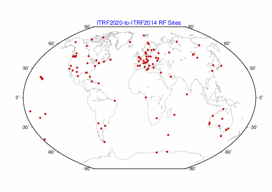
14 transformation parameters from ITRF2020 to ITRF2014 have been estimated using 131 stations listed in the core network list and located at 105 sites shown on $\fig2$.
| T1 mm |
T2 mm |
T3 mm |
D 10-9 |
R1 mas |
R2 mas |
R3 mas |
|
|---|---|---|---|---|---|---|---|
| -1.4 | -0.9 | 1.4 | -0.42 | 0.000 | 0.000 | 0.000 | |
| $\pm$ | 0.2 | 0.2 | 0.2 | 0.03 | 0.007 | 0.006 | 0.007 |
| Rates | 0.0 | -0.1 | 0.2 | 0.00 | 0.000 | 0.000 | 0.000 |
| $\pm$ | 0.2 | 0.2 | 0.2 | 0.03 | 0.007 | 0.006 | 0.007 |
Transformation parameters from ITRF2020 to past ITRFs are available here.
ITRF2020 time series of station position residuals
The ITRF2020 time series of station position residuals are available as tar folders for each of the 4 techniques: DORIS, GNSS, SLR and VLBI.
Within each folder the residual time series for each station are given in three files named as:
- CODE_DOMES.DE (East component)
- CODE_DOMES.DN (North component)
- CODE_DOMES.DH (Up component)
The user should note that these residual time series result from the overall ITRF2020 combination where the station position time series of the 4 techniques were stacked all together. For more information, please refer to the ITRF2020 computation strategy.
ITRF2020 plate motion model
The ITRF2020 plate motion model (PMM) was obtained by adjusting the rotation poles of 13 tectonic plates, together with a so-called Origin Rate Bias (ORB), to the horizontal velocities of 518 ITRF2020 sites.
The estimated plate rotation poles and ORB are available here. Users are advised to add the estimated ORB to the horizontal velocities predicted by the ITRF2020 PMM rotation poles for full consistency with ITRF2020. However, the predicted vertical velocities resulting from the addition of the ORB should be discarded.
The residuals from the ITRF2020 PMM adjustment are available here.
Acknowledgement
The IERS ITRS Center is indebted to the Technique Services (IDS, ILRS, IGS and IVS) and their Analysis and Combination Centers for their contribution by providing reprocessed solutions. The quality of the ITRF2020 is certainly benefiting from technique improved solutions. Many institutions and individuals have also contributed to the ITRF2020 project. We also acknowledge the contribution of DGFI and JPL colleagues to the ITRF2020 analysis. The IERS ITRS Center is particularly grateful to all the institutions that provide the necessary investment for the space geodetic observatories which constitute the main ITRF foundation.
Citation
ITRF2020 paper:
Altamimi, Z., Rebischung, P., Collilieux, X., Métivier, L., Chanard, K. (2023) ITRF2020: an augmented reference frame refining the modeling of nonlinear station motions. Journal of Geodesy, 97(47). https://doi.org/10.1007/s00190-023-01738-w
ITRF2020 plate motion model paper:
Altamimi, Z., Métivier, L., Rebischung, P., Collilieux, X., Chanard, K., Barnéoud, J. (2023) ITRF2020 plate motion model. Geophysical Research Letters, 50(24), e2023GL106373. https://doi.org/10.1029/2023GL106373
When using data through this website, please cite:
Altamimi, Z., Rebischung, P., Collilieux, X., Métivier, L., Chanard, K. (2022) ITRF2020 [Data set]. IERS ITRS Center Hosted by IGN and IPGP, https://doi.org/10.18715/IPGP.2023.LDVIOBNL
Erratum
The UT1 and LOD values initially published with ITRF2020 were discovered to be erroneous. The issue could be traced back to a sign error in the LOD zonal tide corrections applied by the IVS combination center when propagating their ITRF2020 inputs from the middle epochs of the VLBI sessions to noon. The impact of this error on the UT1 and LOD values initially published with ITRF2020 was of the order of a few tenths of milliseconds.
The ITRF2020 EOP time series linked above (i.e., the files named ITRF2020_EOP-F1.DAT and ITRF2020_EOP-F2.DAT) have been updated with corrected UT1 and LOD values on August 9, 2023. Users who downloaded either of those two files before this date are advised to download them again.
As the impact of the error on all other ITRF2020 parameters (pole coordinates and rates, station coordinates) is completely insignificant, all other ITRF2020 files have been left unchanged.